BOSTON — A winter storm will hit Massachusetts on Tuesday, bringing snow, strong wind, and possible coastal flooding.
Winter storm, high wind, and coastal flood warnings have been issued across the Bay State due to heavy snow, strong wind gusts, and the threat of coastal flooding.
Some communities have already canceled school for Tuesday due to the forecast.
STORM TIMELINE
Flakes will start flying around 6 a.m. and ramp up throughout the day, bringing snowfall rates of around 2 inches per hour at its peak, according to Boston 25 Meteorologist Shiri Spear said in her Monday morning forecast. The storm is expected to wind down by 4 p.m. ahead of the evening commute.
“This is when roads will start to get slippery. We’re going to be in the thick of it, with heavy snow falling between 7 or 8 a.m., straight into the early afternoon. You’re going to see that goes until about 3 p.m.,” Spear said. “As we roll into the evening, I’m thinking around 7 p.m. snow should be done for good in the Greater Boston area.”
The worst weather will come through mid morning - early afternoon Tuesday with snowfall rates potentially exceeding 2"/hr at times. Snow will end late afternoon or evening. @boston25 #mawx #boston pic.twitter.com/FGcTKPlrNh
— Shiri Spear (@ShiriSpear) February 12, 2024
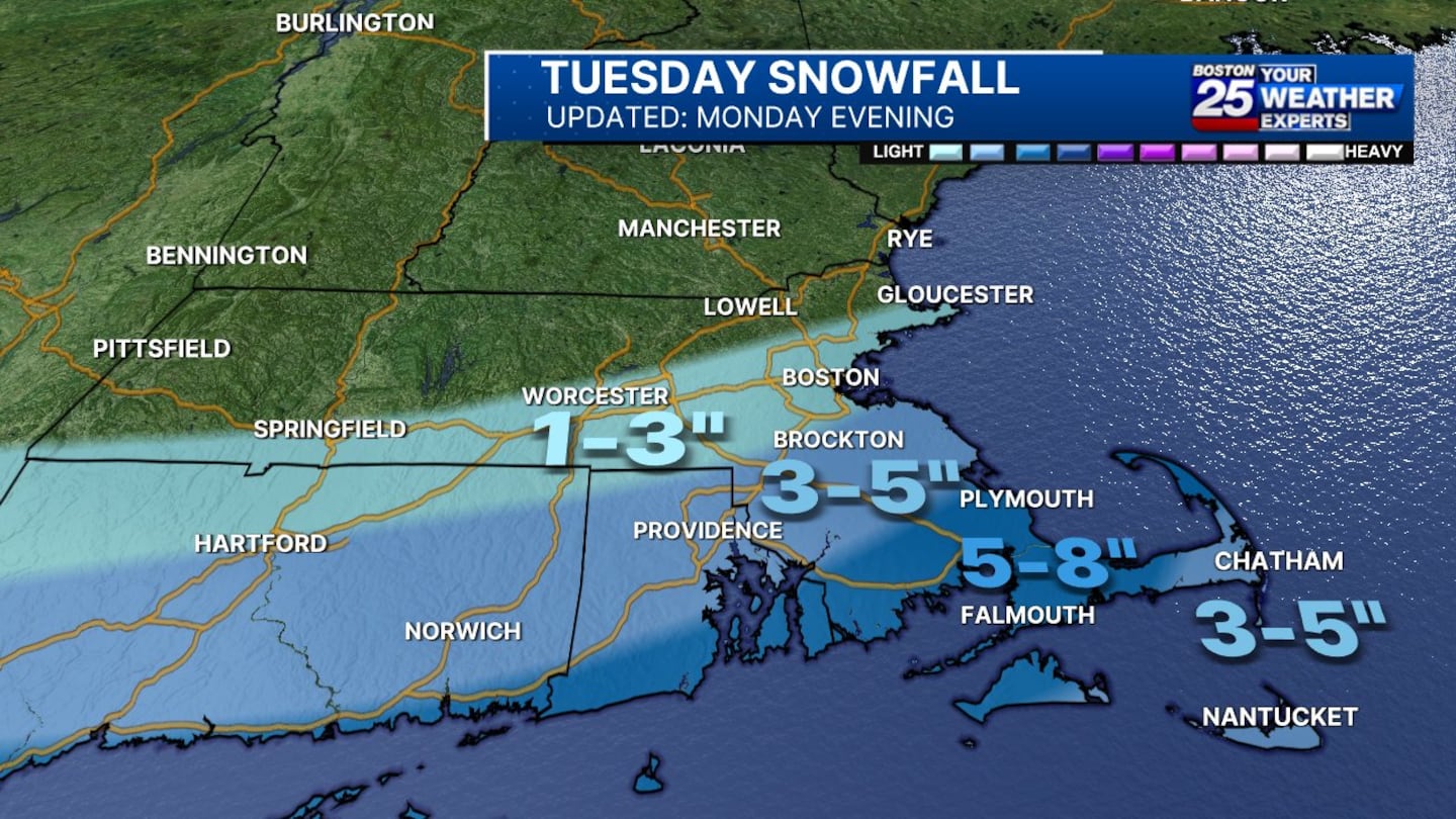
EXPECTED SNOW TOTALS
- Boston and Worcester: 1-3 inches of snow
- Northern Plymouth and Bristol counties: 3-5 inches of snow
- Southern Plymouth and Bristol counties and upper Cape Cod: 5-8 inches of snow
- Rest of Cape and Islands: 3-5 inches of snow
SOUTHWARD SHIFT
In an updated forecast on Monday afternoon, Boston 25 Chief Meteorologist Kevin Lemanowicz said that the latest computer model runs show the storm shifting south.
Lemanowicz said it would be more of a “Cape Cod, Islands, and maybe southeastern Massachusetts big snowstorm,” as opposed to the interior.
“This came as a surprise, but we will always provide you the latest information instead of clinging to an old forecast,” said Boston 25 Meteorologist Tucker Antico.
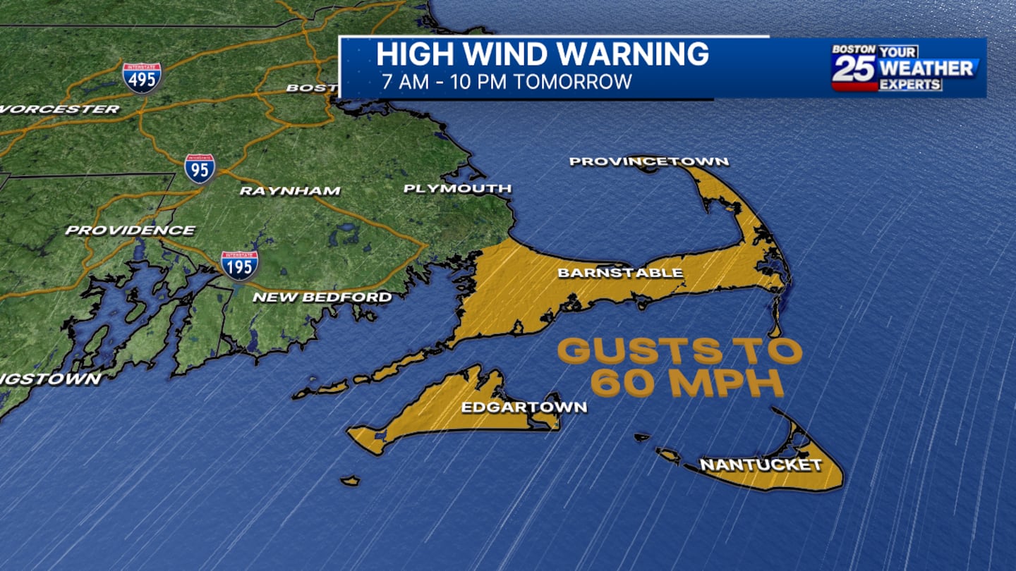
ADDITIONAL STORM THREATS
- High wind warning: A high wind warning for Cape Cod and the Islands. The warning is in effect for Barnstable, Dukes, and Nantucket counties from 7 a.m. to 10 p.m. Tuesday. Gusts of up to 60 mph are possible in the impacted areas.
“On top of the snow, we’ve got some pretty strong winds gusting up 60 mph for the Cape and the Islands,” Spear said.
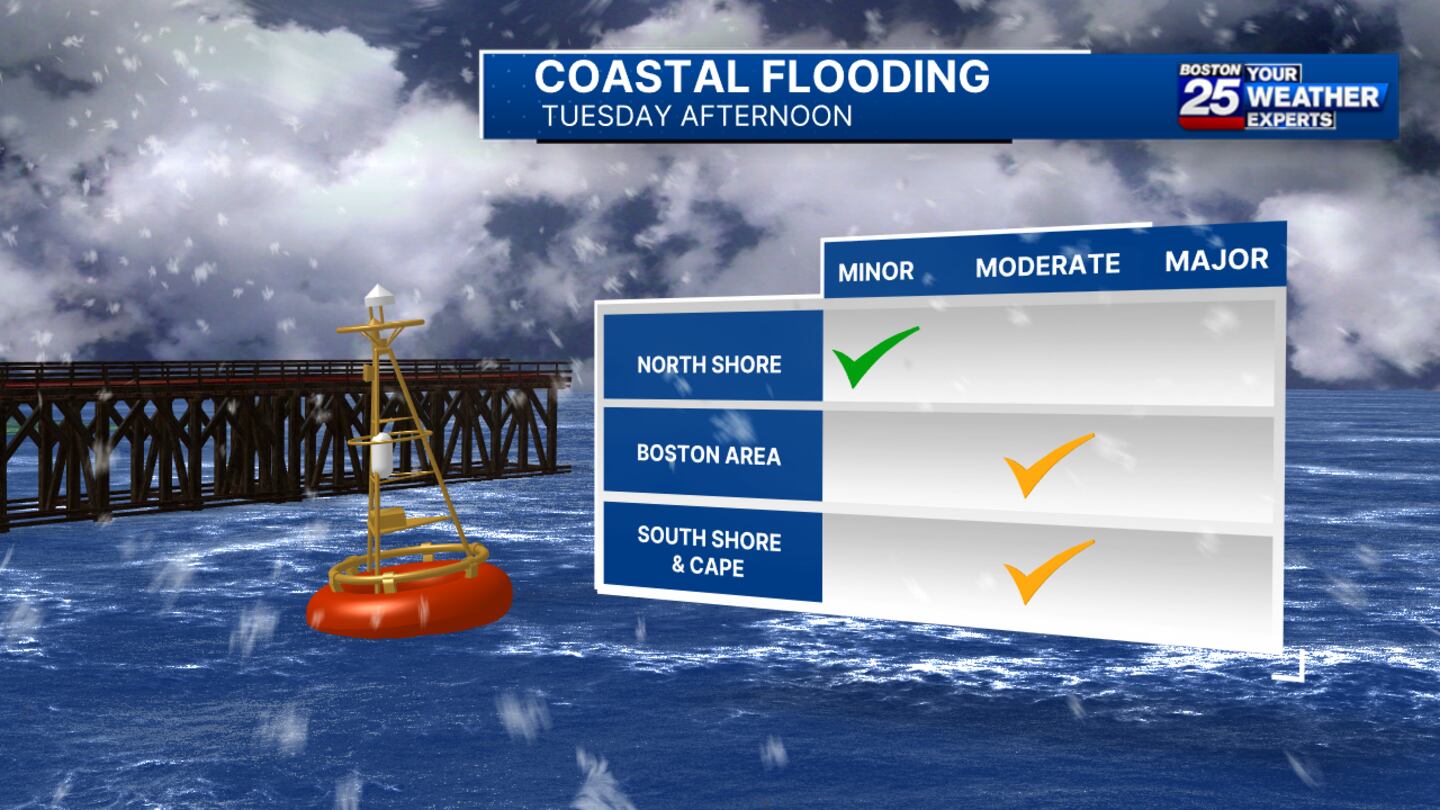
- Coastal flood warning: Towns and cities along the coast of Massachusetts are also bracing for flooding. A coastal flooding warning is in effect for Barnstable, Dukes, Norfolk, Plymouth, Nantucket, and Suffolk counties from noon to 5 p.m. on Tuesday.
“Tomorrow, through the afternoon, we’ve also got a coastal flood warning from Boston down to the Cape and the Islands,” Spear said. “Those of you at the coastline need to be prepared for Tuesday afternoon’s high tide coming in with some big waves, some beach erosion, and some coastal flooding and inundation.”
Minor coastal flooding is expected along the North Shore.
DRIVING CONDITIONS
Roads and highways could be impassable at times on Tuesday.
Spear said in her latest forecast that some of the worst travel conditions will be between 7 a.m. and 3 p.m.
“Travel during that timeframe is going to be very difficult -- between blowing snow, heavy falling snow, and of course snow accumulation on the ground as well,” Spear said.
LATEST MAPS
Stay with the Boston 25 Weather Team for updates as the storm gets closer.
Download the FREE Boston 25 News app for breaking news alerts.
Follow Boston 25 News on Facebook and Twitter. | Watch Boston 25 News NOW
©2024 Cox Media Group
/cloudfront-us-east-1.images.arcpublishing.com/cmg/7QOJU3BNCJERBNKJC5LWTBYFLU.png)


