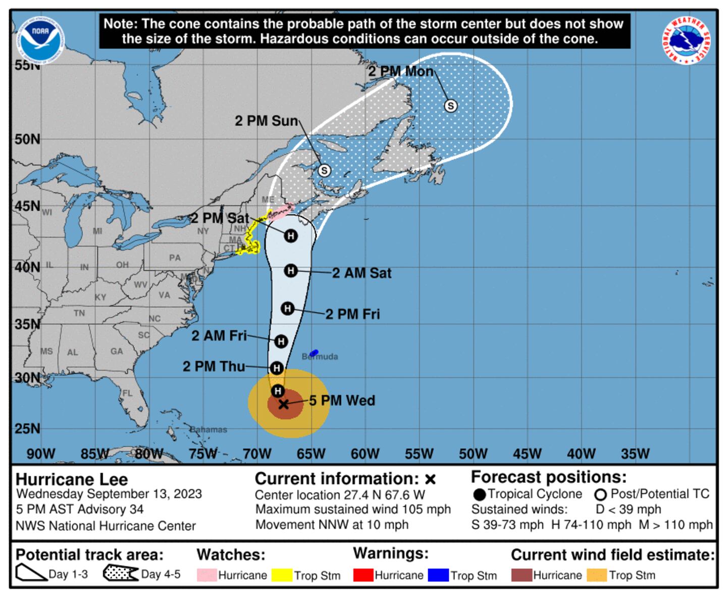
SAN JUAN, Puerto Rico (AP) — Hurricane Lee began to spin away from the northern Caribbean on Wednesday as the Category 2 storm left big waves in its wake and aimed for New England and Atlantic Canada.
The storm was located about 380 miles (610 kilometers) south-southwest of Bermuda. It had winds of up to 105 miles per hour (165 kilometers per hour) and was moving north-northwest at 10 mph (17 kph).
Lee was expected to pass just west of Bermuda, prompting forecasters to issue a tropical storm warning for the island. Wind and heavy rainfall were expected to lash Bermuda starting late Wednesday or early Thursday, forecasters said.
Bermuda’s government announced that public schools would remain closed on Thursday and Friday, and ferry service suspended for Thursday. Most flights also would be suspended starting at Thursday midday.
Lee is then expected to grow in size and keep traveling north as it slowly loses strength in cooler waters. It is expected to approach the coast of New England and Atlantic Canada on Friday and Saturday and remain a “large and dangerous hurricane,” according to the National Hurricane Center.
A hurricane watch was issued for portions of down-east Maine from Stonington to the U.S.-Canadian border. A tropical storm watch was issued for a large swath of coastal New England from Watch Hill, Rhode Island to Stonington, Maine, including Block Island, Martha’s Vineyard and Nantucket. A storm surge watch was issued for Cape Cod Bay and Nantucket.
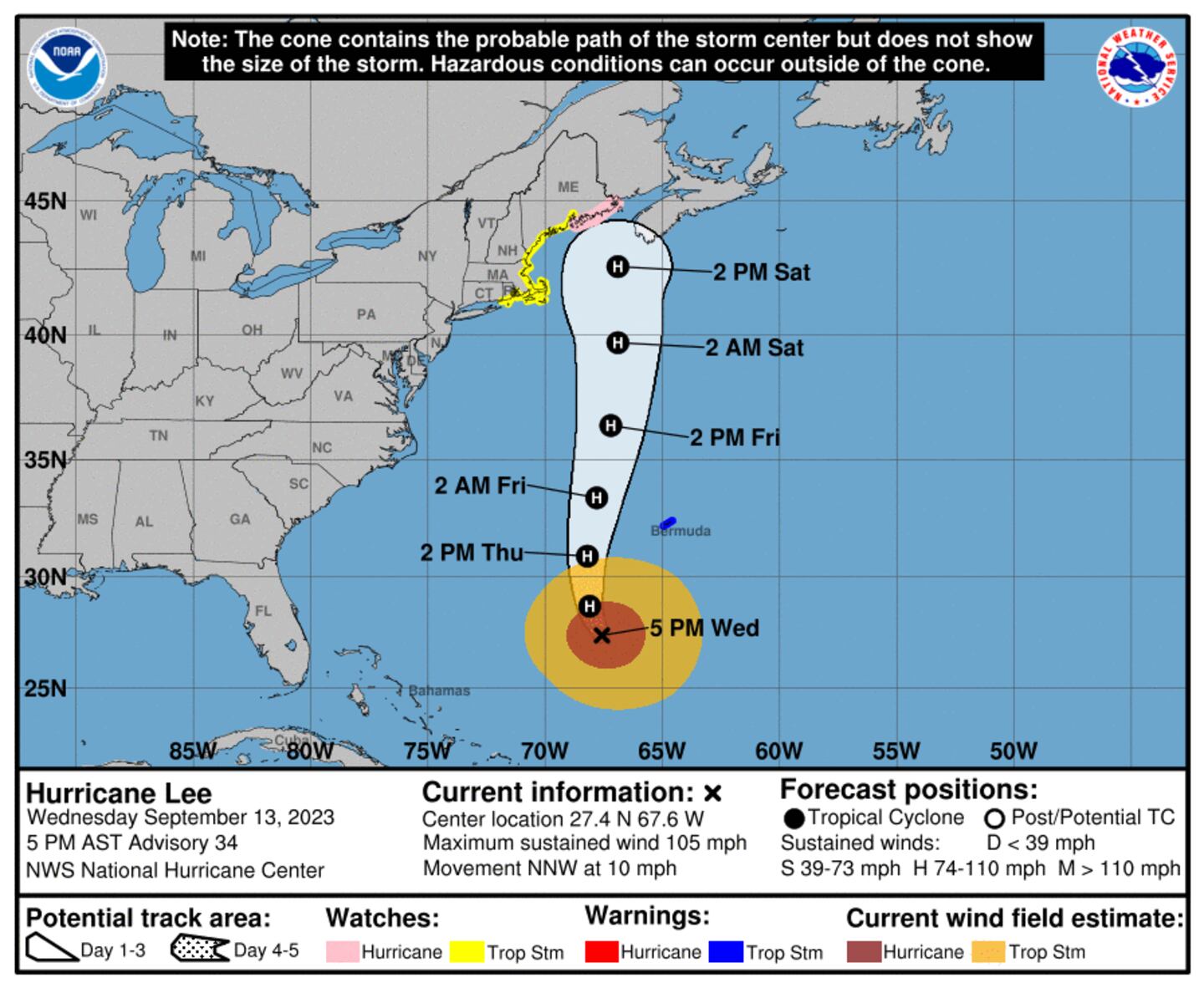
“Due to Lee’s large size, hazards will extend well away from the center, and there will be little to no significance on exactly where the center reaches the coast,” the center said.
Hurricane-force winds extended up to 115 miles (185 kilometers) from Lee’s center, and tropical-storm-force winds extended up to 240 miles (390 kilometers), the center reported. It warned of wind, rain and coastal flooding for parts of New England and Atlantic Canada.
The storm is approaching as New England struggled on Wednesday with flooding from unusually heavy rainfall unrelated to the hurricane that prompted the governor of Massachusetts to declare a state of emergency.
Forecasters warned of dangerous surf and rip currents in Lesser Antilles, the British and U.S. Virgin Islands, Puerto Rico, Hispaniola, the Turks and Caicos Islands, the Bahamas, Bermuda and the U.S. East Coast. The conditions were starting to reach Atlantic Canada.
Meanwhile, Hurricane Margot was spinning through open Atlantic waters on Wednesday. It was located about 790 miles (1,270 kilometers) west-southwest of the Azores and had maximum sustained winds of 90 miles (150 kilometers). It was moving north at 7 mph (11 kph) and is expected to remain over open waters.
It is the 13th named storm of the Atlantic hurricane seasons and the fifth hurricane to form. The season runs from June 1 to Nov. 30 and peaked on Sunday.
The National Oceanic and Atmospheric Administration has forecast 14 to 21 named storms this season. Six to 11 of those are expected to strengthen into hurricane, and of those, two to five could develop into Category 3 storms or higher.
This is a developing story. Check back for updates as more information becomes available.
Download the FREE Boston 25 News app for breaking news alerts.
Follow Boston 25 News on Facebook and Twitter. | Watch Boston 25 News NOW
©2023 Cox Media Group
/cloudfront-us-east-1.images.arcpublishing.com/cmg/7QOJU3BNCJERBNKJC5LWTBYFLU.png)


